For the final stretch of the week, all eyes are on a cold depression that will approach mainland Portugal, bringing a significant change in weather: rain and snow are coming and there will be a risk of thunderstorms and hail.
It is Thursday – April 25th and Freedom Day in Portugal – was the first day of the significant change in the weather predicted by us several days ago, in the weather forecasts that you can consult here. The morning had slightly cloudy or clear skies in mainland Portugal, but the first “signs” of this change, although “shy”, were already felt in the North and Center Regions, thanks to the gradual increase in cloudiness that was observed.
For the cooler environment witnessed on the day of the celebration of the 50th anniversary of the April Revolution, there was a great contribution made by the change in the regime of dominant wind, which started to blow weak to moderate from the Northwestparticularly strong in the western coastal strip, in the Barlavento Algarvio and in the highlands of the Central and Southern Regions.
In certain points on the North and Center coastas they are closer to the sea and for latitudinal reasons are inevitably more exposed to the trajectory of the isolated cold depression coming from Greenland, the occurrence of some weak and scattered showers associated with a first front generated by the depression. Furthermore, the weather has cooled considerably, given the drop in temperatures that took place between yesterday and today.
In the archipelago of Azores, in general, the sky was partially cloudy and with periods of light rain. In the archipelago of Wood the weather outlook was generally dominated by scattered clouds.
The cold depression arrives this Friday in mainland Portugal
Tomorrow – April 26 – an isolated cold depression of an Atlantic nature will approach vertiginously the northwest of the Iberian Peninsula – Galicia (Spain) and Northwest of Portugal (Minho and Douro Coast). Due to the characteristics it presents, the possibility of it being classified as a depression of great impact (if so, it will be named Sancho).
The seas that bathe Europe are extremely hot for the time of year. What consequences could this have for Portugal?

The sky will be quite cloudy and precipitation will occur in several regions of the countrybeing more abundant and intense in areas located north of the Montejunto-Estrela mountain system and especially those located west of the Condensation Barriernamely the districts of Viana do Castelo, Braga, Porto, Aveiro It is western parts of the districts of Real Village It is Viseu. For Minho and Douro Litoral there is, in addition, the risk of thunderstorms and hail.
What is isolated cold depression?
An isolated cold depression is part of the life cycle of an isolated high-altitude depression, especially when it reaches a very mature phase. The main difference is the presence of a well-defined low pressure center at the surface, with its own system of fronts.
Periods of rain or showers in the North and Center interior and in the regions south of Montejunto-Estrelahowever, the precipitation accumulated will be substantially lower, as it is distributed in a very scattered and irregular across these territories of our geography.
Still for this Friday (26) maximum temperatures will drop slightly and it is expected snowfall in the highest points of Serra da Estrela. The wind will blow weak to moderate from the northwest, gradually turning southwest. In the afternoon he will present occasionally strong gusts on the coastal strip south of Cabo Mondego, in Beira Alta, Beira Baixa and Alentejo (up to 45 km/h).

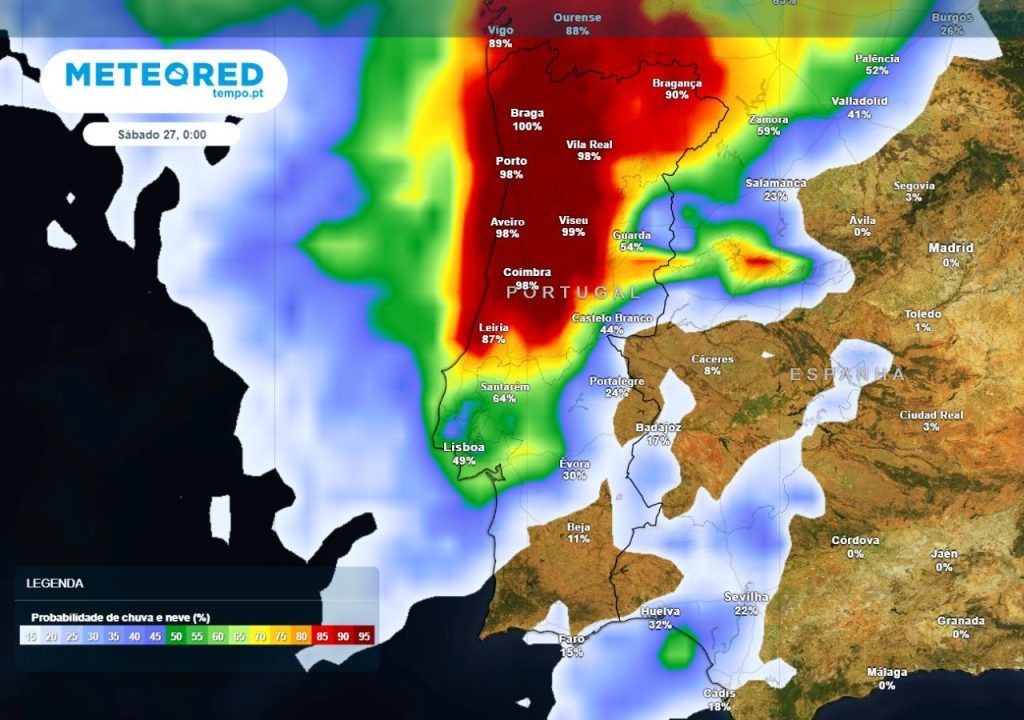
Weekend with rain, possibility of snowfall and risk of thunderstorms, find out in which regions
Until late Saturday morning (27) the sky will be very cloudy. The occurrence of rain or showerssometimes strong and potentially accompanied by thunderstorms and hail in the Regions North and Center.
Glimpse the possibility of snowfall above 1000/1200 meters of altitude, as well as uvapel and/or hail in mountains, mountains, plateaus and locations in the extreme North (Lands of Barroso and Northeast Trás-os-Montes) and interior Centro (Cordilheira Central – with emphasis on Serra da Estrela).

The wind will blow weak to moderate from the west, turning progressively to the northwest. Temperatures will drop again in the North and Center Regions, and south of the Tagus the thermal fluctuations will be insignificant. For Madeira, light rain is expected on Friday afternoon/night and in some periods on Saturday (27), namely early morning, morning and end of the day.
For Sunday, April 28thperiods of very cloudy skies are expected, especially during the afternoon. There will be showers from north to south of mainland Portugalwhich will be more likely throughout the afternoon, and in the form of snow at the highest points of Serra da Estrela.
Although, the frequency and distribution of precipitation will be very scattered and irregular, so not all locations will be watered. For the afternoon period can also be seen the risk of thunderstorm in the North and Center Regions.

Minimum temperatures will drop lightly. It is like even colder weatherit is estimated that favorable conditions for the formation of ice and frost in locations in the Northeast Trás-os-Montes and in Beiras and Serra da Estrela. In several locations in the North and Centerespecially in mountainous areastraining of fog or morning mist.
Tags: cold depression bring rain snow thunderstorms hail affected areas
--


