Atmospheric river will reach mainland Portugal in the coming days, reinforcing the rain in several regions, precisely on some of the most important days of Holy Week. In some regions the 100 mm will be greatly exceeded!
In the first half of this Monday (25) the cold drop that produced adverse weather conditions in the Madeira Archipelago (showers, thunderstorms and hail) approached the Southern region of mainland Portugal where it left instability, with locally intense showers of mud and accompanied by electrical activity. However, even today, this isolated high-altitude depression has been reabsorbed by the polar jet stream.
However, the unstable weather on the Continent has just begun, as we face a Easter week potentially full of adverse weather phenomena.
Weather in Portugal during Easter Week: a sequence of depressions will bring abundant rain, snow and strong wind

This Monday (25th) periods of light rain or showers were recorded across much of the continent’s geography, with locally strong and thunderstorms in the interior of Alentejo and in Algarve due to cold gout. The sudden change in the weather was notable, with thermometers registering a sharp drop in temperatures, which was locally extraordinary in almost all regions..
It has also fallen snow – initially above 1000 meters in altitude – but gradually dropping to medium altitudes (below 1000 meters in the North and Center) in these last hours of Monday (25) due to to the burst entry of the maritime polar air mass.
Tuesday with an authentic winter atmosphere
Tomorrow – Tuesday March 26th – the cold air mass is expected to fully affect the country as it is already fully installed in the territory. Indeed, At high altitudes, our geography will be crossed by a pocket with temperatures of up to -30 or -32 ºC at around 5300 meterswhich will lead to the formation of thunderstorms and the potential development of hail or granular snow.
The weather will remain authentically winterysomething that will also be reinforced by a further drop in temperaturesboth maximum and minimum, and at strong and cold northwest wind.

In addition, periods of light rain, occasionally moderate, or showers that will appear from north to south of mainland Portugal, following the advancement of the cold air pocket. Tomorrow is also the day when a more significant accumulation of snow is expected. The snow level could drop to 500-700 meters in the North and Centerand surprises may even arise in mountain areas in the South Region.
However, we draw attention to the possibility that, in the South, this occurs in the form of hail or granular snow and not snow itself. The most significant snow accumulations will concentrateaccording to the Meteored reference model (ECMWF), in the mountains of Peneda, Amarela, Soajo and Gerês, Terras de Barroso and Cordillera Central.
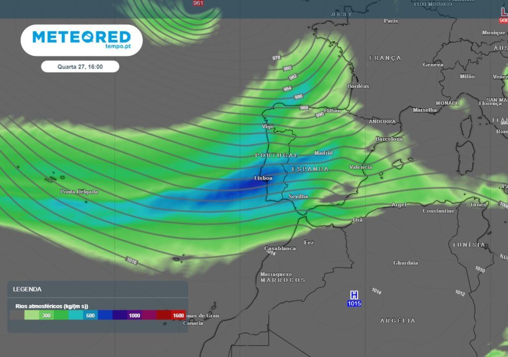
Atmospheric river will reach Portugal from Holy Wednesday: abundant rain forecast for several regions
The snow level will tend to increase gradually throughout the day on Wednesday (27) due to the fact that our country is under the influence of hot and humid abrego (or southwest) winds and rain.
On this day, a large depression trough will develop over the North Atlantic, with a low pressure center associated with the surface, whose main core will be located close to the British Isles. Said barometric depression will drag a atmospheric river towards mainland Portugal, which will increase precipitation in several regions due to high moisture content contained therein.

Between the days of Holy Wednesday (27) and Good Friday (29), frontal systems, reinforced by the atmospheric river, will arrive from the west-southwest, dumping light to moderate rain, which will be more persistent and abundant in the northern regions of the Montejunto-Estrela mountain system and in areas of Alentejo. In some areas it will be strong, with the possibility of occasional thunderstorms. The entire geography of the Continent will be watered “plentifully”, including in regions where it is less common to rain.
More than 150 mm is expected in some areas
The latest update of the model that deserves our greatest confidence foresees a accumulated precipitation exceeding 150 mm in mountainous areas of the Alto Minho It’s from Alto Alentejowith the level of 100mm shall be outdated in almost the entire rest of the continent’s territory, This is an incredible record of accumulated rainfall in terms of the geographical area covered!

The only exceptions should be some areas of the North and Center interior, of AM de Lisbon It’s from Lower Alentejowith rainfall accumulations varying between 50 and 70 mm.
Taking this into account, everything indicates that Many Easter processions will hardly be able to take to the streets in 2024, as this will be the wettest Holy Week of recent years from north to south of mainland Portugal.


