– Advertising – Continue reading below –
O The weather on Tuesday, the last day of April, will be marked by the passage of (more) a frontal surface, with rain, cold weather, some wind, and also the possibility of some instability (thunderstorms) in the late afternoon
After a MONDAY with relatively dry weather, despite being a cool day, Tuesday brings us the return of rain to end this Aprilwhich despite having registered a heat wave in the middle of the month, approximately, I didn’t want to end without also bringing us the usual precipitation what we have become accustomed to
We hope less chance of frost than in previous days, precisely because the cloudiness increases, which will cause minimum temperatures to rise, but the maximum is expected to fall, with some wind, once again accentuating thermal discomfort
– Advertising – Continue reading below –
Since, associated with this depression, we will have a warm front in the early morning and morning, the temperature should prevent snow, even in Serra da Estrela, which should only start to occur after the passage of the cold front, at the end of the day, when, under regime of showers, the snow level could drop to 1200m altitude
In the Azores we are expecting generally dry weather, although in the Western group we can already notice more humiditywhich signals new change on the way
In Madeira, the northwest flow continues, with some humidity, but under slight anticyclonic influence, there should only be minor precipitation on the northern slopes, and calm weather
We can see below, in the MetOffice forecast letter, a complex depression near the British Isles, with associated fronts, which will cause this new change in the weather on the Continent, after a drier day – while in the Azores the effect of the anticyclone should keep the weather relatively stable – detailed forecast below!
WEATHER FORECAST ON TUESDAY, ON THE CONTINENT
– Advertising – Continue reading below –
*** Forecast sponsored by Lina Nails, certified artificial nail technician, located in Pêro Pinheiro, with Russian manicure service, gel polish, acrylic among others! Home service also available! Contact: 965 714 858 ***
SUMMARY: Generally cloudy skies, but open in the interior and southern region in the morning. Periods of rain gradually progress from the coast to the interior, and to the southern region, in the afternoon. Minimum temperature on the way up, maximum on the way down (in general). Some wind. Calm sea
- Skies in general very cloudy, with open areas in the interior and southern regions until the end of the morning. We also expect openings to gradually emerge in the North region after the front passes by mid-afternoon.
- Periods of light to moderate rain during the dawn and early morning on the North and Central coast, gradually evolving towards the Interior from mid-morning, and being occasionally intense, evolving towards the South region in the afternoon (generally weak). Change to showers from mid-afternoon in the North region, with the possibility of thunderstorms in the late afternoonday
- To the Minimum temperatures should rise slightly, while maximum temperatures should drop slightly, especially in the interior
- It will therefore be a day with temperature values maximum temperature of around 12 to 17ºC in most of the territory, with lower values appearing in the North, especially in the Interior, with values in general between 9 and 13ºC – and in some places in the South region the temperature will still exceed the 20ºC, especially in the Algarve
- Lows will be around 7 at 12ºC in most of the territory, to be expected lower values in the North, in the Interior, in particular, (4-6ºC), and slightly higher on the coast (13-16ºC)
- We predict generally weak or no wind in the early morning, becoming moderate from the morning onwards, and occasionally strong in the afternoon, especially on the coast and exposed highlands (3040km/h) and with gusts of up to 55km/h
- A Sea water temperatures remain at around 15ºC on the North West Coast, and 15-16ºC on the rest of the West Coast
- At the Algarve the sea will have a temperature of around 17ºC
- Sea with waves up to around 1m across the West Coast
- On the South Coast of the Algarve we will have waves up to 1m, also
- UV radiation:4 (Moderate)
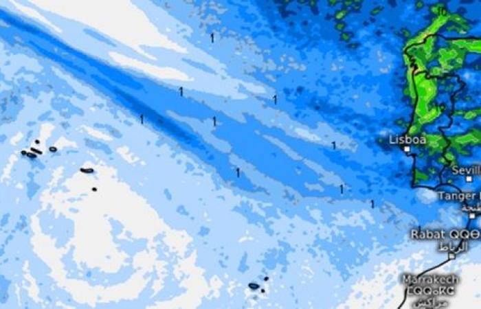
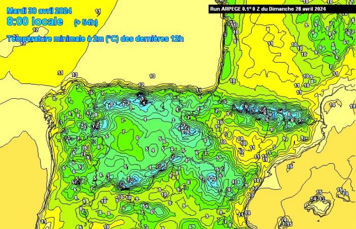
To illustrate this prediction we leave the temperature forecast by the ARPEGE model, which can see a relatively cold day for the season, and precipitation forecast (hour by hour) by the IFS-ECMWF model
Please note that the forecast may differ from reality, it only serves to give an indication from numerical forecast models.
TEMPERATURES ON TUESDAY (ARPEGE)
– Advertising – Continue reading below –

WEATHER FORECAST ON TUESDAY, IN THE AZORES
Summary: This Tuesday, In the Azores, we expect sun, in general, with more cloudiness in the Western islands, with the possibility of drizzle in that same group. Wind generally weak, with the influence of the anticyclone over the archipelago. Mild and very calm weather
- Skies generally slightly cloudy, with some cloudiness present in the Western group of the Azores
- In principle, there should be no precipitation, although some drizzle cannot be ruled out in the Western Islands of the Azores
- Temperatures will rise slightly compared to the previous day, around 1 to 2ºC
- Generally weak wind10 to 20km/h, from Northwest
- We predict temperatures between 14ºC to 16ºC (minimum), It is 17 to 22ºC (maximum), a mild and relatively pleasant day
- Calm sea, with waves generally up to 1m on all islands
- Sea water around 18ºC temperature
- UV radiation: 7-8 (High to very high)
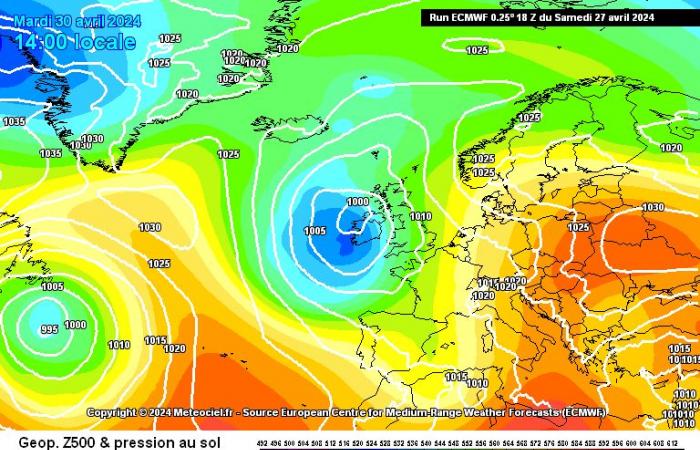
To this day we can see, by the ECMWF model the pressure and geopotential forecast, where we see the anticyclone centered over the Azores archipelago, guaranteeing stability and very calm weather, in general
PRESSURE AND GEOPOTENTIAL – ECMWF, TUESDAY

WEATHER FORECAST ON TUESDAY, IN MADEIRA
Summary: We expect another day for this Tuesday with some humidity in the Madeira, with a Northwest flow, similar to the previous day, with more clouds on the northern slopes and mountainous areas and more open on the southern slopes – and some light precipitation – although not significant – temperatures without major changes – light wind
- Generally cloudy skies (possibility of open weather on south-facing slopes)
- Light showers or periods of rain on the northern slopes and mountainous areas of Madeira Island
- Wind generally weak to moderate, between 10 and 20km/h, from the Northwest – very calm
- We expect maximum temperatures of up to 21 or 22ºC and minimum temperatures between 15 and 18ºC
- UV radiation: 78 (High to very high)
- Sea with waves up to 1 to 1.5m overall
- Sea water at around 21ºC of temperature
A wetter day, with precipitation, clouds in some points more exposed to the slightly wetter flow of the Northwest quadrantwith more open areas on the southern slopes, and in the following days with the expected evolution There may possibly continue to be some humidity, but always with little rain – continue to follow our daily forecasts HERE
We can see in the letter below, by the ECMWF model the evolution of precipitation hour by hour according to this model’s forecast

NEXT DAYS – WHAT TO EXPECT?
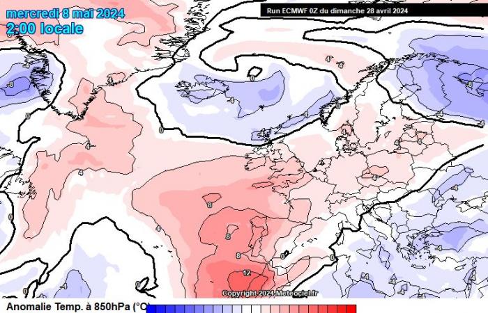
The early summer is over and now we have a late winter? Yes, it’s a little like that! – temperatures are low, and are expected to remain so in the coming days, and with precipitation at least until May 3-4, perhaps with one or two days of interruption
– Advertising – Continue reading below –
You can see this Full forecast available on our website by CLICKING HERE
Both highs and lows should be closer to winter normalsand therefore snow may appear occasionally at altitudes of around 1000 to 1400m at the end of April and beginning of May – the mountains will turn white again, as was the case with Serra da Estrela on Saturday, and it is necessary to monitor the evolution day by day, given the instability in forecasts, to understand at what altitudes it could snow each day
At the beginning of May, stability should gradually returnbut in the period Until May 3-4, we will continue to feel the weather reminding us a little more of Winter, with instability, cool weather, showers, possible thunderstorms and the likelihood of snowfall. Maybe it will be more stable later, but there is still no high confidence in this scenario
April wasn’t great at all, but it still brought us a surprise – the models were very good at predicting this change, which was driven by the final warming of the stratosphere, and temporarily “threw” us back to temperatures close to normal winter temperatures. Given the consensus, it is now a very likely scenario that will continue for at least 56 days
In the Azores the stable weather may now remain stable for a few days, but it is possible that instability will return at the beginning of May – at the moment it is difficult to predict more than 3/4 days in the Azores, the atmosphere is very dynamic – we will see how it evolves!
In Madeira we expect humid weather, the possibility of some precipitation for a few more days…. This pattern could last as long as the anticyclone does not recover, which is not expected for now.
The heatthis, however, He left and shouldn’t be coming back soon
Continue to follow all our forecasts to always stay up to date with all the changes that arise!
For In May, the outlook is warmer again on the Continent – right at the end of the first week, although still an uncertain prediction! – we’ll see how it evolves!

– Advertising – Continue reading below –
FINAL NOTES AND SOURCES USED FOR INFORMATION
UPDATES: For more updates and other predictionsinformation follow the Luso Meteo – Meteorology and Climate page on Facebook HERE
May also follow on TwitterX HERE and on Google News HERE
To help us you can share so we can reach more people!
If you would like to help with donations to the project, to support websitemaintenance costs and subscription services to bring you the best content you can do so, we are very grateful!
You can do it through MBWay to 918260961
Or IBAN for PT50 0007 0000 0029 3216 7422 3
You can also contact us via WhatsApp at 918 260 961 or email
*protected email*
sand want sponsorshipadvertising on our pagesite and for a quote for personalized and detailed forecasts!Thank you very much for your trust and preference!
Sources used for this weather information
Meteologix
Meteociel
MetOffice

