In a few hours, the weather will change drastically in mainland Portugal. First polar air and snow and then the abregos, which will give way to abundant rain and strong wind. Weather conditions will remain adverse throughout Easter Week.
In these last days heat took center stage in meteorology and the almost summer temperatures were in the news – high and significantly above average for the time of year – as well as dust from the Sahara.
Will it snow during Easter Week in Portugal? Polar air could soon leave snow in all these regions

However, in the second half of this Palm Sunday (24)the atmospheric panorama began to change again on the Continent as, the cold drop which has been practically parked for the last three days in the vicinity of the Archipelagos of Wood and the Canarieshe was ris absorbed by the polar jet stream in its rapid movement to the vicinity of the South region from mainland Portugal.
Mainland Portugal will be under the influence of several depressions during Easter Week
During the reabsorption process of the cold droplet into the polar jet stream, a small center of low pressure at the surface developed vertically over our geography, contributing to increased atmospheric instability. Will leave the first irregular showerssometimes locally strong and accompanied by hail It is thunderstorm at the Alentejo interior and in Algarve in the last hours of this Sunday (24th) and the first hours of Monday (25th).
Shortly after the passage of this small depression, a large mass of cold air at altitude – of polar maritime origin – it will descend precipitously in latitude from the North Atlantic and generate strong baroclinic instability in the area around the Iberian Peninsula. “Translating by kids”, a message will be generated fertile ground for the formation of new depressions.
This way, the next depression will develop northwest of mainland Portugalbeginning to affect the country soon after Monday (25). There will be a sharp drop in temperatures (which will be locally extraordinary across vast areas of the territory) immediately after the passage of its cold front. The wind will blow moderate to strong from the north-northwest across the country and is expected snowfall in mountain areas in the last hours of the day.
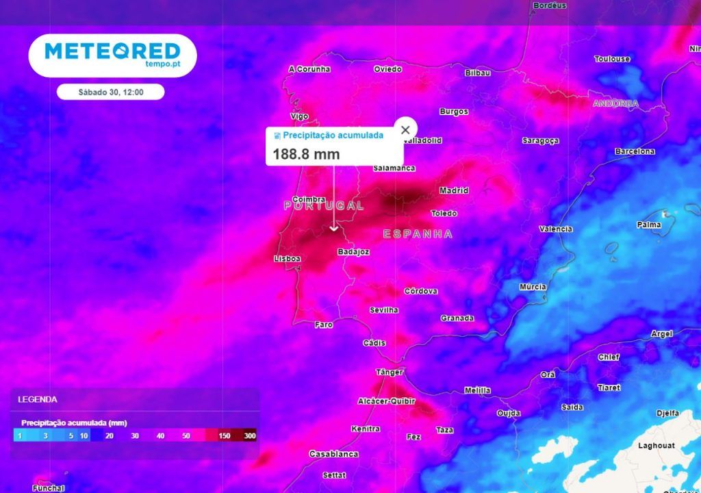
The wind that leaves the most rain in Portugal will impetuously enter Easter Week: more than 150 mm in these regions

A third depression will emerge from Wednesday (27)intensifying the wind storm and dragging a atmospheric river of moisture of subtropical origin that will further reinforce the rain due to the high water vapor content, but this will leave the snow restricted to higher elevations.
The model that deserves our greatest trust (ECMWF) even glimpses the hypothesis of a fourth depression developing over the Easter weekendsomething that, if materialized, would prolong this scenario of instability even further.
Widespread rain, which is expected to be more persistent and abundant in the Center, Alentejo and AM of Lisbon
Taking this prediction into account, precipitation will be relatively frequent and abundant in all territorial units of Portugalincluding Azores It is Woodalthough in the latter it is more occasional and dispersed and more likely in the form of showers.

To the geography of the Continent, the possibility of periods of rain or showers is expected strong and locally persistent during all Easter Weekespecially from the Holy Wednesday (27).
Right now, for the next five days, maps estimate accumulations of more than 50 mm in practically the entire territorybeing reached or exceeded locally the 100 mm in the mountains and mountains that make up the Condensation Barrier, a large part of the Central Region (districts of Aveiro, Guarda, Viseu It is Coimbra partially; White Castle It is Leiria in its entirety), Metropolitan Area of Lisbon, Alentejo Coast, areas of Barlavento Algarvio It is districts of Santarém, Portalegre It is Évora.
Precipitation will manifest itself in the form of snow at relatively low levels during the day on Tuesday (26) – above 600 meters in altitude in the mountains and towns of the North and Center.

The snow level will gradually increase from Wednesday (27) due to the arrival of a warmer air mass of maritime subtropical origin, meaning the possible fall of the white hydrometeor will be sent to points above 1000/1200 meters of altitude. However, the possibility of snow returning over the Easter weekend cannot be ruled out.
Risk of flooding in some areas of the continent
The persistent rain and the dizzying melting of snow in the main mountains and mountain ranges could impact areas historically vulnerable to the occurrence of floodsas well as causing rivers to overflow.
The probability of flooding in historically vulnerable areas and river overflows is greater from Wednesday (27), the day when temperatures are expected to rise, something that will be boosted by the arrival of strong, hot and humid winds from South-west.
In some regions of the country the soils are quite saturated with water, the rivers have very voluminous flows and the dams are full. To this must be added the melting of the snow and, above all, the abundant precipitation in the coming days.
Wind storm: strong gusts are expected
The strong pressure gradient associated with the depressions that will reach our country will contribute to the generation of very strong gusts of windparticularly in areas most exposed to westerly winds. Between the last hours of this Sunday (24th) and Tuesday (26th) gusts of wind will locally 70km/h, especially in Central and Southern Regionsas they are associated with the fronts of the first two depressions.

The strongest gusts are forecast for Wednesday (27) and Thursday (28), with the influence of the third barometric depression in mainland Portugal. Gusts could reach 90 km/h in highlands and mountainous and plateau areas. It is not excluded that this value could be exceeded, but the uncertainty of the coming days prevents a precise assessment of the impact of this depression, which will have to continue to be closely monitored.
Tags: sequence depressions bring abundant rain snow strong wind
--


