
Rising air and ocean temperatures around the world may be setting the stage for a explosive hurricane season in the North Atlantic. In February, the global temperature of the land and ocean surface was 1.40°C above the 20th century averageof 12.1 °C, being the hottest February in 175 years of global climate records from the National Oceanic and Atmospheric Administration (NOAA).
The global average sea surface temperature was recorded highest ever seen, 21.09 °C. It is a trend that has been gaining strengthespecially in the Arctic, where temperatures are warming faster, causing the region to lose the ice of its glaciers.
February 2024 is considered the hottest February on record on the planet
Closer to our geography, the water temperatures of the North Atlantic are much higher than the norml. In an area of the Atlantic known as the main region for hurricane development, sea surface temperatures are well above normal, 0.6 ºC higher than in any other year on record.
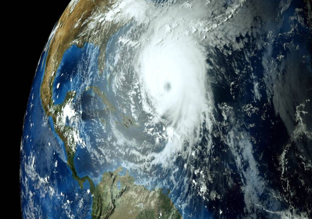
There are just over two months left until the Atlantic Ocean hurricane season, which officially runs from June 1st to November 30thaccording to NOAA, but in parts of this ocean It seems like we’re already in the middle of it. In a strip of ocean where many cyclones are “born”, ocean temperatures in February are closer than one would expect in June.
This unusually ominous heat is raising concerns about another hyperactive hurricane season in the Atlantic. Seven of the last eight seasons have seen above-normal activity.
Last year, similarly unusual heat fueled a stormy season that was significantly more active than the meteorological community anticipatednot even with the presence of the El Niño weather pattern, which emerged last spring, and which tends to inhibit the formation of cyclones in the Atlantic, the season was calm.
The new hurricane season could bring, this year, a new ingredientan increasing probability that a pattern of La Niña replaces El Niño in late summer or early fall. This is another bad sign, as La Niña is associated with active patterns in the tropical Atlantic.
It’s still too early to say whether high temperatures will persist into hurricane season or when La Niña might arrive, but, especially taken together, trends suggest that an active season can be difficult to avoid.
A consistent trend of high average temperatures
Last spring, El Niño gave every indication of a slowdown in hurricane activity in the Atlantic in summer and autumn. This pattern triggers changes in atmospheric circulation that, on the other side of the planet, can hinder the formation and strengthening of tropical storms.
Areas of high pressure with descending air are most common over the Atlantic, and wind shear, when wind speed and direction varies at different altitudes, increases. This factor makes the formation of cyclones difficult.
El Niño vs. Record heat in the Atlantic: what effect had the most weight on the recent 2023 hurricane season?

NOAA even predicted a calmer hurricane season, but as El Niño developed and a unusual heat appeared far beyond the Pacific areas by which the weather pattern is known, forced changes in perspective.
In August it became clearer that ocean heat would likely counteract the typical El Niño effect in the Atlantic, and NOAA updated its forecast. The season ended with around 20% more activity than average.

La Niña happens when wave-like jet streams near the equator move northward, towards the Americas, causing colder water than normal to rise to the surface. This climatic phenomenon results in less wind shear in the Atlantic Ocean and normally contributes to a more active hurricane season.
Fearful prospects for a hyperactive season?
If this trend persists into the upcoming hurricane season, it could mean a conducive environment for tropical waves flowing from Africa to transform into cyclones.
There are several factors that can explain this, one of them is the light winds expected over the Atlantic and which discourage evaporation, which could allow the waters to cooltransferring heat to the air.
Another factor, the fact that surface temperatures tend to remain high, In addition to one more, the prediction that, at the height of the hurricane season, from August to October, precipitation is above normal across the tropical Atlantic.
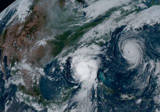
The recently concluded 2023 Atlantic hurricane season was the fourth with the most storms in a year
The last one that we have already explained here, and that Meteored has documented, the scientific community’s prediction for the emergence of La Niñawhich weakens wind shear at high altitude, one of the main ingredients that pave the way for storms to organize and strengthen.
This weather pattern is expected may reach its peak precisely at the height of the hurricane season. This fact, combined with ocean temperatures still abnormally high and which function as the fuel necessary to power hurricanes, could lead to an explosive situation in the North Atlantic basin. It’s a situation to watch!
Tags: High temperatures North Atlantic raise fears hyperactive hurricane season
--


