
Text: Luciana Constantino | FAPESP Agency
With the impacts of climate change increasingly affecting the daily lives of residents of several countries, including Brazil, the resilience of forests, especially tropical ones, such as the Amazon, has been a frequent topic of research. In addition to studying various factors that influence the way vegetation reacts to global warming, scientists seek to improve vegetation models – which are tools with a crucial role in understanding and managing ecosystems, contributing to the conservation of biodiversity and sustainable development .
TV with free IPTV
SAMSUNG Smart TV Crystal 50″ 4K UHD with Alexa
R$ 2,210
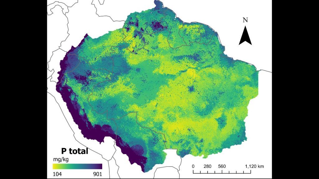
And it is exactly this combination that is described in research published in the journal Earth System Science Data by a group linked to Brazilian institutions. The work resulted in a series of maps that more accurately describe the amount of different chemical forms of phosphorus in Amazonian soil.
“Built” based on a new methodology based on artificial intelligence, the maps confirm that the region has a very low concentration of the mineral. The impact of this is that the lack of phosphorus affects the growth cycle of species and can, for example, prevent trees from reacting to the increase in carbon dioxide associated with climate change.
“When we were working on vegetation models to understand climate behavior in the Amazon, we realized that there was specific information about the amounts of phosphorus in the soil. Typically, in previous methods, these maps only used the types [classes] of soil as mineral predictors. We saw that it would be necessary to include other environmental attributes and, to this end, we developed a new statistical technique, based on machine learning from existing data”, explains the researcher João Paulo Darela Filhowho is currently a postdoctoral fellow at the Technical University of Munich (Germany).
First author of the article, Darela Filho began working on the project when he was completing his doctorate, which he completed in 2021. His research received support from FAPESP through two projects (17/00005-3 It is 19/08194-5).
At the time, its focus was to include in the model Caetê data on nutrient cycles, such as nitrogen and phosphorus, are important for understanding tree growth behavior. Caetê, which in the Tupi-Guarani language means “virgin forest”, is an algorithm capable of projecting the future of Amazonian vegetation, presenting scenarios with forest transformations.
First of its kind exclusively Brazilian, its name comes from the acronym CArbon and Ecosystem functional-Trait Evaluation model, which in free translation is: model for evaluating functional carbon and ecosystem characteristics. There was also support from FAPESP through the AmazonFACEa program that includes field experiments and studies how the increase in atmospheric carbon dioxide (CO2) affects the forest, its biodiversity and ecosystem services (Read more at: agencia.fapesp.br/41424).
Caetê was developed by the team at the Earth System Science Laboratory, at the State University of Campinas (Unicamp), coordinated by professor David Montenegro Lapolawho is also the author of the article with Darela Filho.
“The maps created under the leadership of João Darela are an indispensable step towards advancing our understanding of how tropical forests, which are generally limited by phosphorus, will react to climate change and other human disturbances”, says Lapola to FAPESP Agency.
Results
The researchers used data from 108 locations in the Amazon. They applied an approach based on trained and tested random forest regression models to predict different forms of phosphorus – total, available, organic, inorganic and occluded (when it is bound to other substances). They also used information on reference soil types and other properties, such as geolocation, amounts of nitrogen and carbon, elevation and slope of the terrain, soil pH, average annual precipitation and temperature.
The forest regression models showed average accuracy levels above 64%, depending on the form of phosphorus. For the total mineral, the accuracy reached 77.3%.
The research result showed that the average concentration of total phosphorus found in the analyzed data set was 284.13 milligrams for each kilogram of soil (mg kg−1). The amount is considered low when compared to the global average – 570 mg kg−1. When analyzing the maps, it was detected that the places richest in phosphorus are on the border between the Andes and the Amazon, in contrast to the older soils of the Amazon lowlands, located in the eastern region.
Scientists believe that the new maps can be useful for parameterizing and evaluating models of terrestrial ecosystems, and may even provide answers about the soil-vegetation relationship in the Amazon region.
“Machine learning, with the use of artificial intelligence, will be increasingly applied in science, especially for future projections. Our maps can be used by other researchers to understand how the Amazon will respond to climate change”, adds Darela Filho.
One study international led by Brazilians, including Lapola, and highlighted on the cover of the magazine Nature in February showed that almost half of the Amazon is heading towards a point of no return by 2050, that is, with extreme droughts and deforestation, the forest is expected to lose its resilience.
The research estimated that between 10% and 47% of areas in the region will be exposed to disturbances and threats, potentially triggering “unexpected” transitions in ecosystems and exacerbating regional climate change. Accumulated deforestation, global warming, the amount of annual rainfall in the biome, the intensity of rainfall seasonality and the duration of the dry season were considered as stress situations. The risk is the conversion of the biome into savannah areas, unable to fulfill the role of carbon sequestration.
The article Reference maps of soil phosphorus for the pan-Amazon region can be read at: https://essd.copernicus.org/articles/16/715/2024/.
And the maps are accessible at: https://redu.unicamp.br/dataset.xhtml?persistentId=doi:10.25824/redu/FROESE.


