The beginning of Holy Week was marked by a drastic change in the weather in Portugal, with abrupt drops in temperatures and the return of rain and wind. What will the final stretch be like? Look here!
As mentioned in our forecasts, an atmospheric river will reach our geography today, resulting in rain which should affect the entire Continent, initially in the Center and South regions, then spreading to the North.
Tomorrow the Nelson Depression will bring an almost stationary front that will leave immense millimeters of rain in these regions

As for temperatures, between today and tomorrow there will be a small increase in maximum temperatures in some districts, such as Évora, Porto, Castelo Branco and Portalegre.
However, from Friday these are expected to fall again, in a generalized way, with the weekend is expected to feature wintry temperatures, mainly in the northern and central interior of the countrywhere, on Saturday, the minimum temperatures can drop to -2 ºC in the district of Bragança, followed by 0 ºC in Guarda, with the possibility of snowfall in the highest points.
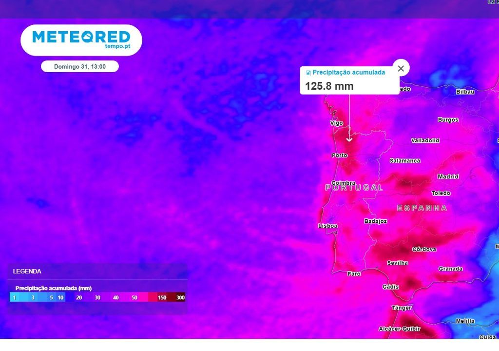
Easter weekend worthy of winter
After a very cold Saturday, especially in the northern and central interior of the country, on Easter Sunday, the lowest minimum temperature is expected to be 1 ºC for Bragança and Guarda, where the thermometer should not exceed 9 ºC and 5 ºC, respectively. The highest expected maximums are expected to reach 16 ºC in Faro, followed by 15 ºC for Lisbon and 14 ºC for Santarém, with the remaining districts not expected to register more than 13 ºC.
In addition to the temperatures worthy of winter, the rain may give some respite for a few hours on Good Friday, mainly in the Center and South of the country, however, the weekend is expected to be quite rainy, precipitation accumulation may exceed 100 mm in a large part of the territoryHowever, the wind is also expected to decrease in speed from Friday onwards.

In addition to the large amount of rain in several places in mainland Portugal, There are some places where these precipitation values will not occur, as is also visible on the map. Among them, the region of Lisbon and Trás-os-Montes, east of the Condensation Barrier, which prevents the passage of humid air masses, coming from the ocean, to that region.
And the archipelagos?
In Madeira and the Azores the scenario is identical in relation to rain, which should continue until the end of the week, albeit with some breaks and the possibility of open weather, in both archipelagos. Temperatures, as usual, will be higher in Madeira, although do not exceed 20 ºC.
IPMA has several yellow and orange warnings active due to sea unrest on the islands, which should be in force by Saturday. At the moment there is a red warning for the Western group of the Azores, where waves from the northwest can reach 20 meters in height. This must be in effect between 3am and 9am on March 28th.
Tags: Final stretch Holy Week Portugal feature lot rain temperatures snowfall find
--


