
After a final stretch of March under the influence of the storm caused by the Nelson Depression, the first days of April will be marked by a sudden change in the weather: a sharp rise in temperatures and abundant rain are expected in these regions.
The Nelson Depression brought a huge storm of rain, cold, snow, wind and sea disturbances to Portugal. It is true that some Easter processions were forcibly cancelled, but this adverse meteorological episode was beneficial for water resources, fields and agricultural crops, dams and reservoirs, and certainly significantly mitigated the drought still present in some places in the south of the continent. . From this perspective, it can be said that spring has started in the best way possible.
First day of April with variable weather conditions
Today, Monday, April 1were the last hours under the influence (albeit indirect) of Nelson Depression and in which the meteorological situation is no longer so unstable. There was weak and irregular showers in a large part of our geography – especially in the North and Central Regions and in particular during the first 12 hours of the day, but in the meantime the sky brought good open weather and good periods of sunshine, although with some cloudiness present.
Weather in Portugal at the start of April: will the rain and cold come to an end?

Occurred snowfall above 800 meters in towns and mountains in the North and Center in the early hours of the day, but with a tendency to persist at higher levels in the Serra da Estrela until late afternoon. Maximum temperatures generally varied between 14 and 17 ºCexcept in the North and Central interior where it was substantially colder. The wind blew from the West-Southwest with occasionally strong gusts, both on the coast and in the highlands.
A significant change in the meteorological panorama is expected
From tomorrow onwards the weather will change radically compared to previous days. The Nelson Depression will have completely dissipated, but the depressions will continue to circulate in the Atlantic even at more northern latitudes (that is, further north, higher) providing the arrival of air masses that are very mild for our latitude.
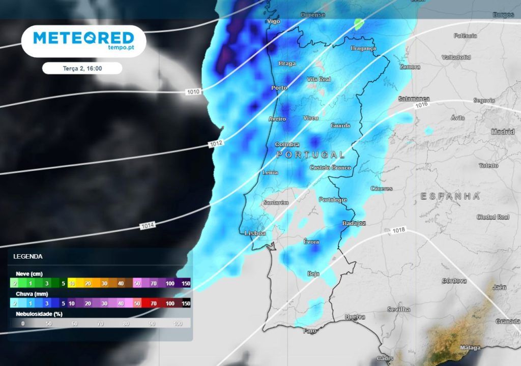
Also this Tuesday – April 2nd – a front will produce periods of rain or showers, first in the Northwest, but extending to the rest of the geography in the following hours and covering mainland Portugal almost from north to south. Only some areas of the Algarve and Baixo Alentejo are expected to escape, with the most irrigated regions being Minho and Douro Litoral.

There will be a general rise in temperatures, especially the minimum temperatures. During the day the thermometer will reach 15 ºC at Harbor17 ºC in Lisbon and 18 ºC in Faro. The wind will blow from the south-southwest, generally weak to moderate, but occasionally strong on the North and Central Coast, where intense gusts of up to 70 km/h will appear. In the highlands, gusts will reach up to 85 km/h.
Between Wednesday (3) and Saturday (6), the element that will take center stage in meteorology will be heat, especially between Thursday (4) and Friday (5), when a sharp rise in temperatures is expected. This will also be associated with a center of high pressure that will allow the weather to remain stable.
A depression that will be located in the Atlantic will drag a mass of hot air towards mainland Portugal and it is likely that the suspended dust will return to our country from Friday (5)being planned for the North and Center interior, Lisbon Metropolitan Area, Alentejo and Algarve and, of these regions, with greater concentration in the districts of Portalegre, Évora, Beja It is Faro.
Water abundance: the state of Portuguese dams in March 2024

Temperatures could exceed 25 ºC in some places in the South in the final stretch of the week
If the current scenario of Meteored reference model come to fruition, both in Friday (5) and Saturday (6) There are places in the southern interior (Vale do Guadiana, Baixo Alentejo and areas of the mountains and barrocal of the Algarve) where the temperature can rise to 25 ºC, or even exceed this level in some areas of the country. These thermal rollercoasters (sudden drops and rises in temperature in short periods of time) are typical of this season of the year.

Regarding precipitationwill occur in the form of weak and scattered showers in areas of the North and Center, more likely and frequent in regions west of the Condensation Barrier and especially during the first 12 hours of the day Wednesday, April 3.
For Thursday (4) and Friday (5) high pressure will dominate, with morning and dense fog in some areas and periods of cloudy or very cloudy skies during a good part of the period and occasionally good open ones. Even so, the possibility of weak and scattered precipitation in Minho and Douro Litoral at a certain point in one of these two days cannot be completely excluded.
Possible return of rain over the weekend and lower temperatures
There still remains a reasonable degree of uncertainty in forecasting weather conditions from Saturday – the 6th – but everything points to a more significant change in the weather coming from the Atlantic next weekend. Temperatures are still expected to be quite high on Saturday (6), with thermometers reaching between 23 and 26 ºC in several areas of Beira Baixa, Alentejo and Algarve, highlighting Baixo Alentejo (Beja district).
Weather in Portugal in April: will it be “a thousand waters”? Will it be cold or hot? Here’s Meteored’s latest forecast
The possibility of an Atlantic front arriving in mainland Portugal from Saturday (6) is expected, which would leave periods of rain or showers in its wake., which may be locally strong and accompanied by thunderstorms and hail. On Sunday (7), due to the arrival of a colder air mass, temperatures will drop significantly and across the board.
Up to 95 mm accumulated in these areas during the week
With the current forecast scenario, the Accumulated precipitation could reach 95 mm in mountainous areas of Minho and geographically surrounding areas (Viana do Castelo, Braga and Vila Real)where the soils are already saturated due to the abundant rain that has occurred over the last few months.
In the rest of the Northwest – as an example, the district of Harbor – expected between 75 and 100 mm. In the remaining regions of the North and Central coast between 30 and 50 mm. In the interior North and Center 15 and 30 mm and south of the Tagus between 1 and 15 mm.

There was a notable improvement in the water situation in mainland Portugal in recent weeks, both in Alentejo and Algarveregions where water was most needed.
Even so, it needs to continue to rain this spring – especially in the district of Faro and particularly in Barlavento – so that water storage levels (fields, dams, reservoirs and for domestic, agricultural, energy and tourist consumption) are not jeopardized during the summer season and so that summer can be faced with more optimism.
Tags: April starts sudden change abundant rain expected regions
--


