
– Advertising – Continue reading below –
Unstable weather in the next few days with two depressions, the first which already affected us this Friday and continues this Saturday, the 27th, and the Second which will affect us later in early May
This second depression could condition the weather for around 3 days, between the 1st and 3rd of May, with rain, more snow in the mountains, the possibility of thunderstorms and some wind
We thus predict cold weather for April, occasional rain (and snow, at varying altitudes, but which can temporarily reach 1100-1200m), some occasional thunderstorms on some days, particularly in the afternoon, not expected to be severe – at least for already
– Advertising – Continue reading below –
This first depression begins to affect France this Saturday, and will generate circulation favorable to an episode of violent rains – lasting 4 to 5 days – which could cause very serious flooding. However, she was not nominated by Météo-France, despite the expected effects
All this will be accompanied by some wind, which accentuates the thermal sensation – mainly on Saturday, the 27th, and again with the second depression predicted, for the end of the month and the first 2 days of May
On the part of the ECMWF model, we leave, from now on, the animated forecast (GIF) of pressure and geopotential that shows us exactly what will happen – the passage of several disturbances, in a scenario more typical of Winter than exactly the middle of Spring!
UNSTABLE WEATHER – RAIN, COLD, THUNDERSTORMS – SUMMARY UNTIL MAY 3
For this prediction we used a combination of several models, including some “traditional” models and new “machine learning” models. The truth is that they all present somewhat similar predictions, so the prediction is even a little more reliable!
The depressions that will affect us should not be named, as, at the date of the forecast, they do not meet criteria for nomination by any responsible agency. Even so, after affecting Portugal tThey also affect the North of Spain and France, with some intensity, so it is not completely impossible for one of these agencies to name one of the depressions, and this would not alter the forecast in any way.
– Advertising – Continue reading below –
In summary, we foresee the following conditions for Portugal
SATURDAY APRIL 27
- On Saturday we will have intermittent precipitation, with a special incidence in the afternoonwith showers and possible localized thunderstorms (DO NOT SEVERE), some hail and snow, in the early hours of the morning it could fall to 900m in the North region, something unusual at this time of year, and perhaps 1100 or 1200m in the Center region, rising to 1200 to 1400m in the afternoon
- The highest mountains in these 2 days can accumulate up to 5 to 10cm of new snow – very good for this time of year. Fortunately, snow does not fall in the lower lands, nor do we expect frosts these days – unfortunately they may appear in the following days…
- We wait for the increase in the intensity of the wind, which starts to blow strongly during the day on Saturday, sometimes with gusts of up to 70km/h on the coast and 80km/h in the highlands, especially in the early morning, and again in the afternoon
- The sea may have waves up to 56m on the West Coast
SUNDAY APRIL 28 AND MONDAY APRIL 29
- These days we wait open, and maximum temperatures rise slightly
- On the other hand the lows drop a little
- So it is likely that there will be frosts located in the North and Center Interior, unfortunately
- Despite the open, especially on Sunday, in the afternoon, showers are likely, and even thunderstormshail, with snow in the highest points of the mountains (Above 14001500m)
- It should be noted that These thunderstorms should not have the same severity as the thunderstorms we had around April 20th, as we have much less energy in the atmosphere – yet the unpredictable dynamics require careful monitoring
- Some wind, nothing very relevant, but making the thermal sensation even lower
- O sea with some agitation, but calming down a little, waves up to 23m
TUESDAY, APRIL 30 AND WEDNESDAYTHURSDAY, MAY 123
Uncertainty in evolution, but According to most models, we should see the passage of a front on Tuesday, April 30th (rain more consistent in the North and Center, less in the South) followed by showers and thunderstorms on May 1st, with a relatively intense frontal aftermath according to most models
Snow is likely to fall again in the highest mountains
– Advertising – Continue reading below –
On the 2nd of May, it is very likely that there will be a new front, with a further increase in the intensity of rain, and a further increase in wind, as well as some sea agitation, which should be followed by a period of showers that will continue until the 3rd. of May, maybe even May 45
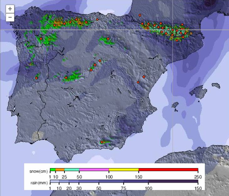
To illustrate the prediction we leave the map of total rainfall accumulated for these days using the ECMWF model, and what a beautiful irrigation in the North and Center, especially on the coast, and, despite being a little further south, it is good for maintaining moisture in the soil!
We also leave the snowpack forecast by SnowForecast for the next 3 days
SNOW UNTIL APRIL 30 – FORECAST
SnowForecast Map – snow forecast in more detail for the following days, if necessary, will be updated
WHAT IS THE ORIGIN OF THIS SITUATION? WHY IS THE WEATHER SO UNCERTAIN?
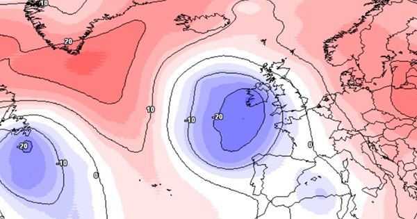
This air mass originates in Greenland, then descends in a NorthwestSoutheast flow, due to the rise of the Azores anticyclone to the North
You Blocking to the north, which is what we will experience in the coming days, is common when we have a disturbed, weak jet stream. We are still feeling the effects of the sudden warming of the stratosphere in March, which ended up greatly affecting the polar vortex, and we are also feeling the effects of the final warming of the stratosphere, before the summer. Together with the end of El Niño and the transition of seasons make this time of year particularly unstablewith sudden changes (effectively accentuated by climate change) and with extreme
It’s true that we are predicting cold and rain, but that doesn’t mean it will be like this the entire month of May
– Advertising – Continue reading below –
We don’t have a forecast yet, so just an example, still without any reliability, but despite the snow now nothing prevents it from being very hot after 5 or 6 days, perhaps close to the record values of the season – this is what we have seen all over the world, sudden and extreme variations, and it is likely to happen here too – but the forecast for May will only be in a few days when there is more certainty!
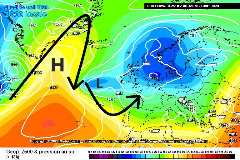
For now, the graph below should help you understand why this is the case, Always remember that anticyclones rotate clockwise, and depressions the opposite (in the Northern Hemisphere) with H representing high pressure, and L low pressure!
IS FROSTS VERY LIKELY TO OCCUR?
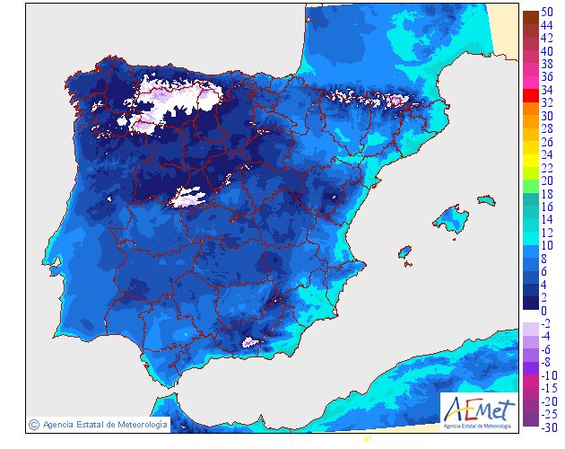
Unfortunately according to the most reliable model we have, yes, it is likely (ECMWF)
The type of flow promotes humidity, and the temperature appears to be low enough for frost to form on drier days
If we were at our limit a few days ago, this ended up being limited because the soils were hot, and the nights only cooled down later. This is not the case now, we actually have weather that resembles winter
Like this especially on the 28th and 29th, frost is very likely to occur, and then, on other days, depending on whether precipitation occurs or not, it may also occur
In the days 28 and 29 is more likely simply because we predict clearer skies in some places in the Interior and drier weather at night, with night temperatures below those indicated by the AEMET model (Below 5ºC in practically all regions of the Interior, locally even reach close to 0ºC, can even reach negative values in places marked in white)
AFTER THIS INSTABILITY, WHEN WILL SEASONAL TIME RETURN?
As we have already reported We still don’t have a concrete forecast. The most reliable models indicate a progressive rise in temperature from the 3rd/4th of May, with the installation of the anticyclone, but unstable – that is, probability of thunderstorms, or even the continuation of the passage of more fronts, and variability
– Advertising – Continue reading below –
For now seems a credible probability, and it is likely, or even very likely, that around the second week of May we will already have some heat, but we also do not rule out dust, and thunderstorms – the anticyclone is not able to establish itself yet, especially as the blockage in northern latitudes
So the May weather, unstable and hot, is likely to appear – the cold leaves us, the instability not so
However It is necessary to monitor and understand how the anticyclone recovers after this instability – everything still seems to be possible, from a scenario of low temperatures persisting, to a scenario of more intense heat
O The most likely scenario is the one mentioned, hotter, somewhat unstable, and with dust – something that is no stranger to us in recent times
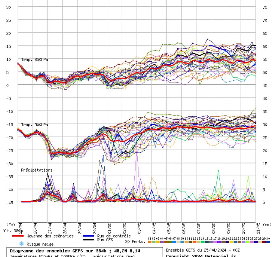
The forecast The GEFS model average does indicate a rise in temperature and instability, but we can see the ensemble lines “in a mess”, which indicates uncertainty. You should wait for the May monthly forecast coming soon for more details, and follow our daily forecasts day by day HERE
Thank you very much for your trust and preference!
FINAL NOTES AND SOURCES USED FOR INFORMATION
UPDATES: For more updates and other predictionsinformation follow the Luso Meteo – Meteorology and Climate page on Facebook HERE
May also follow on TwitterX HERE and on Google News HERE
To help us you can share so we can reach more people!
If you would like to help with donations to the project, to support websitemaintenance costs and subscription services to bring you the best content you can do so, we are very grateful!
You can do it through MBWay to 918260961
Or IBAN for PT50 0007 0000 0029 3216 7422 3
You can also contact us via WhatsApp at 918 260 961 or email
*protected email*
sand want sponsorshipadvertising on our pagesite and for a quote for personalized and detailed forecasts!Thank you very much for your trust and preference!
– Advertising – Continue reading below –
Sources used for this weather information
Meteologix
Meteociel
SnowForecast
Wetterzentrale


